At that morning the weather changed to get better and we continued our
trip to the north. Leaving Ullapool we used only small roads next to the
shore line to cross the very rough and romantic landscape of Assynth.
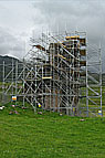
At the Ardvreck Castle we stopped. Although the weather was cold and the
remains of the castle where enclosed by a scaffold we surrounded the ruins
and took some photos from the castle and the great landscape around.
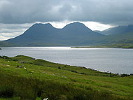
After asking the map we intended to rest at the next parking place located at the saddle
of Quinag which seemed to have a good view to Unapool and Kylestrome.
Indeed the panoramic view from this place was overwhelming but it was uncomfortable and too windy for a rest. So we continued the tour
to Kylestrome and there in the valley we found a nice place. Shielded of
the wind and while the sun started to shine we assembled our
camping stove and prepared a good meal.
The last some miles before reaching Laxford Bridge the roughness of the landscape
increased to an impressive mess. Bizarre strange rocks mixed with swamped
hollows
and the road was downright burst into this wild landscape.
I liked to drive this road.
Ten years ago we had have to turn at Laxford Bridge. Now we had time enough to
explore the northern coast of Scotland. And so we continued our trip to the north.
Passing Rhinconich the roughness of the landscape changed into wide valleys with
large Moors. From time to time we saw indications of peat earning
as draining ditches and stacked peat (for drying).
Originally we wanted to turn left in Keoldale to visit Cape Wrath, the
most north western edge of Scotland with its famous Cliff.
Unfortunately Cape Wrath it closed to the public because the marine air forces
misuse
it as an bombing area. So we sorrowfully fed a trusting seagull with
apple pieces next at the ferry dock and then we drove to Durness.
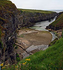
The walk along the sandy beach "An Fharaid" was only a short one because it
started to rain again. So we went shopping some food and
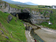
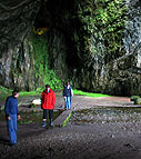
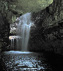
visited the "Smoo Cave", the large mouth opening of an under
earth bourn
flowing into the sea. The cave is romantically located at the end of a
canyon shaped
by the bourn and contains a waterfall and a small lake. Usually its possible to
visit the deep parts of the cave by boat but today it was too late. From this moment
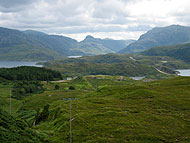
we were also looking for a camp ground. Going on we surrounded the very
beautiful Loch Eriboll. The single track road winds itself through small hills with
blooming meadows and gives free different views to the Loch and the
mountains around.
And the best of all was the absolutely loneliness and silence.
We wanted to stay overnight in Tongue but it was impossible to find the
camp ground
as well as the ostensible most northern outdoor growing palm tree of Europe.
It was quite late in the afternoon as we pitched our tent in Betty Hill.
Tomorrow we'll take a day off!